
CONFIGURATION INDEX
| Item | Configuration |
|---|---|
| Document | help.html |
| Markdown source / build | help_R02.md / B261109 |
| File revision / build | R003 / B261109 |
| Content revision / build | R001 / B261013 |
| Date | 2026-11-09 |
| Approved source application | SPOTMAP v0.9.9R01 FIX1 |
| Standalone application | n/a |
| Source display / package build | B261013 / 2026101303 |
| Standalone package build | n/a |
| Status | Prepared for project-owner review; not uploaded. |
Generic information
- The offline app help stays available even when not connected to internet.
- The online web help requires an internet connection.
- This is a reference tool only and not a substitute for knowledge, experience or approved operational data; always strictly use, adhere, follow and verify with approved operational data.
- If you do not have a FULL understanding of the tool, do not use it!
How to use the help section
🔴Disclaimer: A disclaimer is a legal statement designed to limit a company's liability or specify the boundaries of a product's warranty. It informs the user about what the product or company is not responsible for, or clarifies that certain information (like third-party software updates) is outside of the company's control. Impact: Legal/Financial. It protects the organization from lawsuits and sets realistic expectations for the product's performance or usage.
⚠️Warning: A warning alerts the user to potential hazards that could result in personal injury, death, severe data loss, or permanent damage to equipment. It is the most critical type of callout and must clearly explain the hazard, the consequences of ignoring it, and how to avoid it. Impact: High. Ignoring a warning can lead to physical harm or catastrophic system failure, or both.
🔼 Note: A note provides helpful, non-critical information to the user. It emphasizes points, clarifies steps, or offers background context that is not essential to completing the main task but improves the user's understanding. Impact: Low. Ignoring a note will not cause harm, damage, or data loss.
INTRODUCTION
SPOTMAP records a geographic track, marks observations, and brings survey tools together on a reference map. This page explains the main screen and links to the detailed help for each tool.
BASIC USAGE
1. Read the live information
Before recording, check the position, location source, accuracy, and fix age. The information rows show latitude, longitude, GPS altitude, track, ground speed, accuracy, fix age, source/rate, Z Time, recorder status, track-point count, POI count, and the current message.
Z Time is the timestamp of the latest received location fix, in UTC, displayed as Zhh:mm:ss. It remains at that timestamp if fixes stop; Fix Age continues to increase. Before a fix is available, the time shows dashes.
The track readout shows a direction only with a fresh usable fix and adequate motion. Below 3 kt it displays a dash. T* identifies a movement-qualified derived bearing when receiver course is unavailable. These direction-display rules do not stop recording low-speed or stationary fixes.
2. Use the top toolbar
The toolbar runs from left to right:
- LAYERS — show or hide background maps, recorded information, rings, grid, and imported references.
- SETUP — configure source labels, map presentation, rings, ownship, and backups.
- HELP — open this offline guide and the online-help directory.
- IMPORT — choose supported geographic reference data from Files. A
.spotmapbackground package uses LAYERS → IMPORT / REPLACE instead. - SWATH — configure the recorded coverage strip and inspect target-area progress.
- CAMERA — assign and prepare cameras, inspect readiness, and run a camera test.
- WIND — estimate wind from a GPS turn and optionally send the result to the map.
- XWIND — calculate runway headwind/tailwind and crosswind components from manual inputs.
- TOOLS — open the 3 × 3 grid of additional tools.
3. Adjust the map
Pan and zoom to inspect the reference map. TRACK UP keeps the direction of travel toward the top; turning it off gives North Up. CENTERED follows the ownship position. Reset View restores Track Up, Centered, and a 4.0 NM-wide view.
The ownship is the live position symbol. A magenta path is recorded history; the optional wet noodle is a prediction. The two red distance/time rings are configured in SETUP. Imported reference names may be shortened on the map for readability; the original files remain unchanged.
🔴Disclaimer: SPOTMAP's maps and calculated overlays are for reference only, not for navigation. A displayed background or old track does not establish that the current GPS fix is fresh.
4. START, PAUSE, and STOP
- START begins recording. After a pause, START resumes the same recording and opens a new track segment.
- PAUSE suspends track recording while keeping previously recorded information visible.
- STOP seals the recording and requests its final save. Wait for the saved status before exporting or starting a new session.
- The START and PAUSE clocks show cumulative time in recording mode and paused mode, in decimal hours. They are not speed-based flight-time calculations. Both freeze on STOP and reset for a new recording.
Pauses, genuine GPS gaps, changes of source, timestamp discontinuities, and recovery can create track-segment boundaries. The map and supported exports retain those boundaries instead of drawing a false connector across a gap.
The displayed history is not limited to the most recent five minutes. Older display geometry may be reduced at wide zoom for performance; close views restore raw detail, and track exports retain the recorded samples.
5. MARK an observation
Tap MARK to capture the observation moment, including its available position, time, altitude, speed, accuracy, source, and ground track. Then choose FRONT, LEFT, RIGHT, or REAR, followed by the POI type. Read any GPS or save message before assuming the observation was saved.
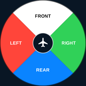
The initial MARK tap also requests captures from the configured cameras. Camera capture and POI selection are separate: a camera request is not proof that a photo was stored, and a camera problem does not make a valid POI disappear. Check camera readiness and playback through CAMERA.
A mark without a usable captured course can retain its location and relative direction, but cannot supply a geographically oriented arrow or observation sector. A valid 000° course is a real northward direction, not missing data.
When Circle-to-Fix is enabled, FLAG TURN appears beside MARK. It saves the currently available estimated center and full circle while recording. See CIRCLE-TO-FIX help.
6. REVIEW the session
Open REVIEW to inspect logged POIs and session messages. It can be used while recording. It does not substitute for the Survey Notes notebook or the Meshtastic conversation history, which have their own screens.
7. EXPORT a saved snapshot
Pause or stop and wait for the required save. Open EXPORT, choose a format, and save/share the generated file. For a wind-only workspace, export can also become available when a sent wind is present and the save conditions are satisfied.
- KML — geographic data for a compatible viewer. Main-session KML may use online icon URLs, so custom symbols are not guaranteed without internet.
- KMZ — packaged geographic data with the app's required marker artwork; the preferred single-file format when those custom symbols must travel with the export.
- GPX — recorded geographic track/point data for compatible applications.
- CSV — tabular session data.
- JSON — structured master data retaining the detailed SPOTMAP session information.
For KML/KMZ, select the appropriate compatibility profile. Normal retains the usual timestamp elements. Google Earth Web is the profile intended for that viewer. The profile changes the outward export, not the saved recording master.
Only the selected format is generated. A completed export is kept locally even if sharing is canceled. Unchanged exports may be reused. An export is a snapshot: later marks or sent winds belong in a later export.
Saved Circle-to-Fix geometry and coverage are included in applicable main-session KML/KMZ exports. Sent Wind results and their measurement tracks are included; unsent Wind attempts are not. Survey Notes, Camera logs, and Meshtastic logs require their own export controls.
8. Check saving and backups
Saving happens independently of Export. Open SETUP → BACKUP to inspect durable-save status and use RETRY SAVE if an error is reported. SAVED SESSIONS / BACKUPS provides review, export, and copies of retained masters, journals, and exports.
Keep independent copies of important data. Do not use an intentional force-quit as a normal recording or save step. Background recording depends on the system delivering usable location updates; check the resulting track after testing a receiver or a change in app state.
9. Start a new session
After STOP and a successful save, open TOOLS → NEW SESSION. Export what you need, then confirm NEW SESSION to return to the splash and acknowledgments. This resets the active session and sent winds. It does not mean every independent tool's stored data are deleted. See NEW SESSION help.
10. Help directory
Use the document links to open the related help, or the online links to visit the corresponding website pages.
| Help | Markdown | Online page |
|---|---|---|
| LAYERS | layers | layers.html |
| SETUP | setup | setup.html |
| SWATH | swath | swath.html |
| CAMERA | camera | camera.html |
| WIND | wind | wind.html |
| XWIND | xwind | xwind.html |
| TOOLS | tools | tools.html |
| PIVOTAL ALTITUDE COMPUTER | pac | pac.html |
| A to B | atob | atob.html |
| PR/D | prd | prd.html |
| MESSAGES | messages | messages.html |
| CIRCLE-TO-FIX | ctof | ctof.html |
| SURVEY NOTES | surverynotes | surverynotes.html |
| SWATH PLANNER | swathplanner | swathplanner.html |
| AIRPORT FINDER | airportfinder | airportfinder.html |
| NEW SESSION | new | new.html |
Tap X to close help and return to the underlying screen.
ABBREVIATION
- CSV — Comma-Separated Values.
- GNSS — Global Navigation Satellite System.
- GPS — Global Positioning System.
- GPX — GPS Exchange Format.
- JSON — JavaScript Object Notation.
- KML — Keyhole Markup Language.
- KMZ — A ZIP archive containing KML and any packaged resources.
- kt / kts — Knot / knots.
- NM — Nautical Miles.
- POI — Point of Interest.
- UTC / Z — Coordinated Universal Time / Zulu time.
DEFINITION
- Fix — A position sample with a timestamp and associated information.
- Track — Direction of motion over the ground; also, in context, the recorded path.
- Segment — A continuous portion of a recorded path, separated from other portions at an interruption.
- Snapshot — A fixed copy of the session at a particular time/revision.
- Master — The structured session data retained by SPOTMAP.
- Compatibility profile — An export option adapting outward KML/KMZ content for a target viewer.
- Session message — A recorded app event/status entry, distinct from a radio conversation.