CONFIGURATION INDEX
| Item | Configuration |
|---|---|
| Document | swath.html |
| Markdown source / build | swath_R02.md / B261109 |
| File revision / build | R003 / B261109 |
| Content revision / build | R001 / B261013 |
| Date | 2026-11-09 |
| Approved source application | SPOTMAP v0.9.9R01 FIX1 |
| Standalone application | n/a |
| Source display / package build | B261013 / 2026101303 |
| Standalone package build | n/a |
| Status | Prepared for project-owner review; not uploaded. |
Generic information
- The offline app help stays available even when not connected to internet.
- The online web help requires an internet connection.
- This is a reference tool only and not a substitute for knowledge, experience or approved operational data; always strictly use, adhere, follow and verify with approved operational data.
- If you do not have a FULL understanding of the tool, do not use it!
How to use the help section
🔴Disclaimer: A disclaimer is a legal statement designed to limit a company's liability or specify the boundaries of a product's warranty. It informs the user about what the product or company is not responsible for, or clarifies that certain information (like third-party software updates) is outside of the company's control. Impact: Legal/Financial. It protects the organization from lawsuits and sets realistic expectations for the product's performance or usage.
⚠️Warning: A warning alerts the user to potential hazards that could result in personal injury, death, severe data loss, or permanent damage to equipment. It is the most critical type of callout and must clearly explain the hazard, the consequences of ignoring it, and how to avoid it. Impact: High. Ignoring a warning can lead to physical harm or catastrophic system failure, or both.
🔼 Note: A note provides helpful, non-critical information to the user. It emphasizes points, clarifies steps, or offers background context that is not essential to completing the main task but improves the user's understanding. Impact: Low. Ignoring a note will not cause harm, damage, or data loss.
INTRODUCTION
A swath (pronounced /ˈswäth/) is a long, broad strip, belt, or path of something, such as grass cut by a mower, a streak of color, or a large geographic region.
SWATH estimates the ground covered by a selected strip along the recorded path, clipped to imported survey areas. It shows viewed and remaining coverage and lets you set the strip's width and side.
BASIC USAGE
1. Prepare and import coverage areas
For the app to recognize an imported KML polygon as a SWATH area:
If created in Google Map (or similar tool):
| Setting | Required value |
|---|---|
| Boundary / line color | Orange #FFAA00 |
| Area / fill color | Orange #FFAA00 |
| Area opacity | Exactly 80% — equivalent to 20% transparency |
| Fill | Enabled |
- Line width and line opacity do not affect recognition;
- Use an opaque outline for visibility only;
- Use a closed polygon, not an open path (minimum 3 vertices);
- All KML files imported as a SWATH, but not matching the boundary line color, and the area color and opacity will be displayed, but not recognized as an active SWATH area to survey.
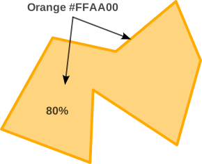
If editing the KML directly (with a text editor or similar):
- Orange fill at 80%:
cc00aaff - Orange outline at 100%:
ff00aaff
The NOT VIEWED (not covered) areas remain orange, opacity at 80%. The app generates the green VIEWED coverage automatically.
Create the boundaries in SWATH PLANNER or with a side tool, export as KML only (KMZ will not work), and load that file through the main IMPORT control. Qualifying areas have 3–50 boundary vertices, no holes, an orange #FFAA00 outline, and an orange fill at 80% opacity.
Open SWATH and check the number of coverage areas found. If none are found, check the imported file and area styling. An arbitrary reference polygon does not automatically become a coverage area.
2. SWATH WIDTH
Select ft or m, then move the slider or tap the bordered width value to open the keypad. The physical range is 50–3,000 ft, equivalent to 15.24–914.40 m.
- The first typed digit replaces the previous value.
- DONE applies a valid width and updates the slider.
- X or a tap outside the keypad cancels that edit.
- The keypad accepts whole feet from 50 to 3,000 or whole meters from 16 to 914. The slider also reaches the exact physical endpoints.
- ≈ identifies a rounded display. Switching units preserves the exact physical width, as does pressing DONE without changing the entry.
3. SWATH LOCATION
Choose the side relative to the recorded direction of travel:
- Left — the full selected width extends to the left.
- Center — half the selected width extends to each side.
- Right — the full selected width extends to the right.

For example, 100 ft / Center covers a strip 50 ft to each side; 100 ft / Left places the whole 100 ft on the left. Width and side changes affect future valid recorded passes. They do not redraw earlier coverage using the new setting.
4. Record and read coverage
Use the main START control to record. Coverage is calculated from valid recorded path segments inside the loaded qualifying areas. Overlapping passes count the same ground only once. Changing display zoom does not change the coverage geometry.
- VIEWED is the covered proportion of the loaded target area.
- REMAINING is the uncovered proportion.
- Viewed ground uses green
#55FF7F; not-viewed ground uses orange#FFAA00, both at 80% fill opacity. Original boundaries remain orange. - PAUSE and STOP retain the accumulated coverage. They do not record a connecting swath across the interruption.
🔼 Note: Coverage represents the configured strip along the recorded path. It does not verify that a camera actually captured an image or that the ground was visible.
5. Read status and retained-area behavior
Check the status for loading, saving, geometry, or capacity messages. Earlier grid-based coverage, when present, is identified as approximate; its original within-cell shape cannot be recovered.
Area progress is retained independently of the imported filename/collection. Adding another area preserves progress on existing areas. Newly imported areas do not receive coverage retroactively from an earlier track. Clearing the reference collection removes the loaded display but keeps saved area progress for later reimport.
6. RESET COVERAGE
Tap RESET COVERAGE, then confirm Reset Coverage to clear viewed progress for all currently loaded areas. Cancel keeps it.
⚠️Warning: Reset intentionally starts the loaded areas from zero. Unloaded saved areas, source KML files, recorded flights, and historical exports remain. Use this action only when you intend to begin a fresh survey of the loaded areas.
7. Close and export
Tap DONE or the card's X to return to the map. Coverage continues when the main session is recording.
After pausing or stopping and completing the required save, use the main EXPORT controls to export the session. KML/KMZ include the recorded coverage. A paused/stopped recording snapshot retains its coverage state; later imports or resets do not rewrite an already generated historical export.
ABBREVIATION
- ft — Feet.
- GNSS — Global Navigation Satellite System.
- KML — Keyhole Markup Language.
- KMZ — A ZIP archive containing KML and any packaged resources.
- m — Meters.
DEFINITION
- Swath — The ground strip assigned to a recorded pass.
- Coverage area — An imported target boundary that meets SPOTMAP's coverage requirements.
- Viewed — Target ground already swept by valid recorded swaths.
- Remaining — Target ground not yet swept.
- Clipping — Restricting a swath to the portion inside the target boundary.
- Vertex — One point defining a polygon boundary.
- Hole — An excluded interior region within a polygon.