
CONFIGURATION INDEX
| Item | Configuration |
|---|---|
| Document | prd.html |
| Markdown source / build | prd_R02.md / B261109 |
| File revision / build | R003 / B261109 |
| Content revision / build | R001 / B261013 |
| Date | 2026-11-09 |
| Approved source application | SPOTMAP v0.9.9R01 FIX1 |
| Standalone application | n/a |
| Source display / package build | B261013 / 2026101303 |
| Standalone package build | n/a |
| Status | Prepared for project-owner review; not uploaded. |
Generic information
- The offline app help stays available even when not connected to internet.
- The online web help requires an internet connection.
- This is a reference tool only and not a substitute for knowledge, experience or approved operational data; always strictly use, adhere, follow and verify with approved operational data.
- If you do not have a FULL understanding of the tool, do not use it!
How to use the help section
🔴Disclaimer: A disclaimer is a legal statement designed to limit a company's liability or specify the boundaries of a product's warranty. It informs the user about what the product or company is not responsible for, or clarifies that certain information (like third-party software updates) is outside of the company's control. Impact: Legal/Financial. It protects the organization from lawsuits and sets realistic expectations for the product's performance or usage.
⚠️Warning: A warning alerts the user to potential hazards that could result in personal injury, death, severe data loss, or permanent damage to equipment. It is the most critical type of callout and must clearly explain the hazard, the consequences of ignoring it, and how to avoid it. Impact: High. Ignoring a warning can lead to physical harm or catastrophic system failure, or both.
🔼 Note: A note provides helpful, non-critical information to the user. It emphasizes points, clarifies steps, or offers background context that is not essential to completing the main task but improves the user's understanding. Impact: Low. Ignoring a note will not cause harm, damage, or data loss.
INTRODUCTION
PR/D converts geographic coordinates and calculates a point's bearing/radial and distance from airport or navigation-aid references. Reference searches use a locally imported facilities database.
BASIC USAGE
Open TOOLS → PR/D. The calculation uses the entered point, independently of the aircraft's live position and main recording.
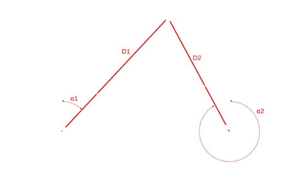
The point will be referenced against Reference 1 (α1, D1) and Reference 2 (α2, D2), where α is the bearing of the radial from the reference, and D is the distance from the reference to the point.
1. USER POINT and coordinate format
Enter latitude and longitude in the upper DD fields, or choose DDM or DMS for the lower fields. Use the correct N/S and E/W hemispheres; signed DD entries use minus signs for south and west.
Tap CONVERT to apply the entry and update the other coordinate representation. The EDITING · CONVERT TO APPLY indication means the current draft must be committed. Correct validation errors before relying on results.
The eraser clears the point and releases keyboard focus so you can enter a new point or reference. It does not remove the imported database.
2. FIND NEAREST
After entering a valid point, tap FIND NEAREST to calculate nearby eligible database references. Import the facilities database first if no database is available; its control is described below.
The nearest-search inventory includes the builder's eligible open airports and operational navigation-aid/ILS facilities. A database inventory can also contain records that are not eligible nearest-search candidates. A nearby reference is not automatically a usable landing site or a currently available navigation aid.
3. REFERENCE and FIND
To use a specific reference, enter an airport or navaid identifier, such as KDFW or TTT, in REFERENCE, then tap FIND. If several records match, choose the intended facility from the list after checking its type, name, location, and status.
Changing the user point invalidates the old result. Apply the entry and run the appropriate search again.
4. RADIAL / BEARING FROM
The result is the initial bearing from the database reference toward the user point, plus horizontal WGS84 geodesic distance in NM. This direction is not the reciprocal bearing from your point back to the reference.
Choose the north-reference mode:
| Mode | Meaning |
|---|---|
| AUTO | Uses WMM2025 modeled magnetic variation when available; labels a true-bearing fallback explicitly. |
| TRUE | Reports the initial geodesic bearing relative to true north. |
| WMM | Uses WMM2025 at the reference location and selected date when available. |
| FAA PUB | Uses the reference's published database variation/epoch when supplied; otherwise labels a true-bearing fallback. |
For AUTO or WMM, set WMM2025 date (UTC) to the intended calculation date. The app's model-validity check covers 2025-01-01 through 2029-12-31; outside that interval, or when the model cannot supply a usable variation, the result identifies its fallback. Always read the basis label, not just the numerical angle.
⚠️Warning: Modeled magnetic variation and published variation are not proof of a VOR's actual station alignment or a match to a particular avionics database. AUTO does not certify a station radial. Verify the applicable reference and approved data before any operational use.
5. Result cards and Details
Each card identifies the facility, type, bearing basis, and distance. Expand Details to see the facility name/status, coordinates, true azimuth, applied offset, explanation, published variation/epoch, and coordinate role.
A dash or UNDEFINED can indicate coincident points or a non-unique shortest-path azimuth. It must not be read as 000°. Use the explanation to understand the result.
6. SAVE KMZ and SAVE KML
- SAVE KMZ packages the result geometry and its point/airport/navaid artwork in one file.
- SAVE KML writes the geographic result using viewer-default markers without a local icons-folder requirement in this app reference build.
Choose a destination in Files. Export is available for a valid current result; changing the input requires recalculation. Numerical reference information remains associated with the exported geometry.
7. FAA DATABASE
At the bottom of the card, tap DATABASE, then IMPORT .PRDDB. Select the facilities file produced by the SPOTMAP FAA PR/D Builder, using the naming pattern:
SPOTMAP_US_YYYY-MM-DD_r00X.prddb
PR/D does not require the .afdb runway companion used by Airport Finder. Each tool stores its own validated database copy; importing into Airport Finder does not automatically replace PR/D's database.
Inspect the filename, effective date, next-cycle date, facility/candidate counts, and CURRENT CYCLE, FUTURE, or OUTDATED status. Expand Database details for its version, build, and source information. Import a replacement file through the same control when you have an appropriate update; there is no in-app database-download control here.
Coordinate conversion works without a database. After a valid database import, reference searches work offline. The original file in Files remains unchanged.
8. Close the card
Use Done to end keyboard entry and X to close. The current in-app point, draft, and results remain available when the card reopens. PR/D does not control GPS recording or create a main-session POI.
ABBREVIATION
- DD — Decimal Degrees.
- DDM — Degrees and Decimal Minutes.
- DMS — Degrees, Minutes, and Seconds.
- FAA — Federal Aviation Administration.
- GPS — Global Positioning System.
- ILS — Instrument Landing System.
- KML — Keyhole Markup Language.
- KMZ — A ZIP archive containing KML and any packaged resources.
- NM — Nautical Miles.
- POI — Point of Interest.
- PR/D — Point Radial / Distance.
- UTC — Coordinated Universal Time.
- VOR — Very High Frequency Omnidirectional Range.
- WGS84 — World Geodetic System 1984.
- WMM — World Magnetic Model.
DEFINITION
- Reference — The database facility from which bearing and distance are calculated.
- User point — The entered geographic position being described relative to the reference.
- Bearing basis — The true or magnetic convention actually used for the displayed angle.
- Magnetic variation — The angular difference between true and magnetic north under the selected source/model.
- Epoch — The date associated with a published reference value.
- Geodesic distance — Horizontal surface distance along the shortest WGS84 ellipsoidal path.
- Station alignment — The directional alignment of a radio navigation aid, which may differ from present modeled magnetic variation.
- Eligible reference — A database record admitted by the nearest-search selection rules.