CONFIGURATION INDEX
| Item | Configuration |
|---|---|
| Document | atob.html |
| Markdown source / build | atob_R02.md / B261109 |
| File revision / build | R003 / B261109 |
| Content revision / build | R001 / B261013 |
| Date | 2026-11-09 |
| Approved source application | SPOTMAP v0.9.9R01 FIX1 |
| Standalone application | n/a |
| Source display / package build | B261013 / 2026101303 |
| Standalone package build | n/a |
| Status | Prepared for project-owner review; not uploaded. |
Generic information
- The offline app help stays available even when not connected to internet.
- The online web help requires an internet connection.
- This is a reference tool only and not a substitute for knowledge, experience or approved operational data; always strictly use, adhere, follow and verify with approved operational data.
- If you do not have a FULL understanding of the tool, do not use it!
How to use the help section
🔴Disclaimer: A disclaimer is a legal statement designed to limit a company's liability or specify the boundaries of a product's warranty. It informs the user about what the product or company is not responsible for, or clarifies that certain information (like third-party software updates) is outside of the company's control. Impact: Legal/Financial. It protects the organization from lawsuits and sets realistic expectations for the product's performance or usage.
⚠️Warning: A warning alerts the user to potential hazards that could result in personal injury, death, severe data loss, or permanent damage to equipment. It is the most critical type of callout and must clearly explain the hazard, the consequences of ignoring it, and how to avoid it. Impact: High. Ignoring a warning can lead to physical harm or catastrophic system failure, or both.
🔼 Note: A note provides helpful, non-critical information to the user. It emphasizes points, clarifies steps, or offers background context that is not essential to completing the main task but improves the user's understanding. Impact: Low. Ignoring a note will not cause harm, damage, or data loss.
INTRODUCTION
A to B calculates the horizontal distance and true direction from Point A to Point B. Each point can be entered manually or captured from GPS; results include geodesic and rhumb-line calculations. See the knowledge section, at the end of this page.
BASIC USAGE
Open TOOLS → A to B. The tool uses its own points and results without controlling the main recorder.
1. USER POINT A
Enter latitude and longitude in the upper DD fields, or select DDM or DMS and use the lower fields with the correct N/S and E/W hemispheres.
- DD uses signed decimal degrees; south and west are negative.
- DDM uses degrees and decimal minutes.
- DMS uses degrees, minutes, and seconds.
- CONVERT applies the entry and updates the other coordinate representation. Correct any validation message before computing.
- The eraser clears Point A and its capture information. It does not clear Point B.
2. Capture Point A from GPS, if desired
Tap Capture from GPS to request the position at the capture-button touch time. The app uses its existing location feed and may wait for a suitable following fix so it can interpolate between fixes around that time.
The displayed capture information identifies its timestamp and whether it used a GPS fix or interpolation. Tap that information for details. A and B may wait independently; COMPUTE is unavailable while a capture is pending.
The capture policy allows a maximum 10-second span between the bracketing fixes, a 15-second wait, and endpoint reported accuracy of 50 m or better. Interpolation assumes steady motion along the short geodesic between samples; the endpoint accuracy values do not establish the actual accuracy of the interpolated position. Read an error or timeout rather than treating the previous point as a new capture.
3. USER POINT B
Set Point B using the same fields and controls. Its CONVERT, GPS capture, and eraser act on B independently. Check both points and hemispheres before continuing.
4. COMPUTE A to B
Tap COMPUTE A to B after both points are valid. The button reports WAITING FOR GPS… or COMPUTING… when applicable. Results refer to travel from A toward B.
5. Read the two result groups
- Orthodromic (great circle) distance is the WGS84 geodesic distance, shown in NM and feet. The associated bearing is the initial azimuth from A.
- Loxodrome (rhumb line) distance is the distance along a constant-bearing surface path, also shown in NM and feet. The associated heading is that constant true bearing.
All distances are horizontal surface distances on the reference ellipsoid. They are not slant ranges, and the displayed directions are true-north references without a wind correction. Read any result note for coincident points or other ambiguous cases.
Changing a point invalidates the previous calculation. Apply the new entry and compute again before exporting.
6. Save the result
- SAVE TXT writes a readable report of the points and computed results.
- SAVE KMZ packages the geographic output and its custom point icons in one file.
- SAVE KML writes a geographic file using viewer-default point markers; no companion icons folder is required in this app reference build.
The geographic export includes the endpoint connector. Its intended line style is yellow; marker appearance in a plain KML depends on the viewer. Use KMZ when the packaged custom artwork is needed. Choose the destination in Files and check the save confirmation.
7. Close and reuse
Use Done to finish numeric editing and X to close the card. Points are retained, and reopening the card retains the current in-app result. An already requested capture can finish after the card closes; app inactivity cancels pending captures. A to B does not start, pause, stop, or reset the main session. Manual calculation requires no network or database.
KNOWLEDGE
For the A to B tool, the two results describe two different routes between the same points:
- Orthodromic distance + initial true bearing: the shortest surface route on a spherical Earth, together with its direction at departure from A.
- Loxodromic distance + constant true bearing: the distance along a route whose direction relative to true north remains constant from A to B.
The central clarification is that both bearings are true bearings:
- “Initial” identifies where the bearing applies;
- “true” identifies its reference—true north.
The geometry behind them is as follows:
| Characteristic | Orthodrome — great circle | Loxodrome — rhumb line |
|---|---|---|
| Route geometry | An arc of a circle whose center coincides with Earth’s center | A curve that crosses meridians at a constant angle |
| Distance | The shorter great-circle arc gives the shortest surface distance on a sphere | Generally longer |
| Direction relative to true north | Generally changes along the route | Remains constant |
| Appearance on a Mercator map | Generally curved | Straight |
| Main advantage | Minimum geometric distance | A single true course for the whole leg |
These distinctions are established navigation concepts. The straight appearance of a rhumb line on Mercator is a property of the projection; it does not make that route the shortest on the globe. [1][2][3]
- Equal distances: the routes coincide when traveling along the equator or directly north/south along the same meridian.
- Spiral shape: an oblique rhumb line, extended indefinitely, spirals toward a pole. However, an east/west rhumb line follows a parallel of latitude, and a north/south rhumb line follows a meridian. Therefore, not every rhumb line is a spiral. [1]
When to use each distance?...choose according to the route you want to describe.
- Use orthodromic distance when the question is “How far apart are A and B by the shortest surface route?” This is the natural choice for direct geographic separation and a useful baseline for long-haul aviation or oceanic route planning. The distance saving becomes particularly relevant for routes covering substantial longitude at higher latitudes. Actual routing may depart from it to accommodate obstacles, restrictions, weather, or favorable winds and currents; the shortest distance does not necessarily produce the shortest travel time. [2]
- Use loxodromic distance when the question is “How far will I travel if I follow one constant true course from A to B?” It is convenient for plotting individual legs on Mercator charts and for traditional coastal navigation. A straight line drawn between A and B on a Mercator chart represents this route. [3]
For short legs away from the poles, the distance difference is often very small. There is no universal distance at which you must switch: latitude and route orientation also matter. [2]
When to use initial azimuth versus constant true bearing?...keep the bearing paired with its corresponding route.
The initial azimuth is the direction of the great-circle route as you leave A. In this context, it means initial true bearing, measured clockwise from true north: 000° north, 090° east, 180° south, and 270° west.
It answers: “In which direction does the shortest route toward B begin?”
As you progress, the local true course generally changes. Holding the departure value throughout the trip would therefore generally take you away from the great-circle route. The initial azimuth is not an average bearing or an instruction to maintain one heading until arrival. [2][5]
The rhumb-line bearing is the constant true course of the entire rhumb-line route. It answers: “Which single direction relative to true north describes this route from A to B?”
Unlike the great-circle initial bearing, that value remains applicable along the whole planned rhumb line. [3]
For an aircraft, course and heading must remain distinct:
| Term | Meaning |
|---|---|
| True course | Intended direction of travel over the ground, referenced to true north |
| True heading | Direction the aircraft’s nose points, referenced to true north |
| Track | Actual path or direction of movement over the ground |
Wind correction converts the desired true course into the true heading needed to maintain it. Consequently, a rhumb line has a constant true course, but changing winds may require changing headings. A constant magnetic compass heading also does not guarantee a constant true course: magnetic variation and compass deviation must be accounted for. [4]
A numerical example makes the distinction clearer. Consider hypothetical points:
- A at 50°N, 60°W and
- B at 50°N, 0°. Using a spherical Earth with a mean radius of approximately 6,371 km:
| Result | Great circle | Rhumb line |
|---|---|---|
| Distance | 2,251 NM | 2,316 NM |
| True course leaving A | 066.1°T | 090.0°T |
| True course halfway along the route | 090.0°T | 090.0°T |
| True course approaching B | 113.9°T | 090.0°T |
| Latitude halfway along the route | Approximately 54.0°N | 50.0°N |
The great circle initially travels northeast, reaches a higher latitude, and approaches B southeastward. The rhumb line travels due east along 50°N throughout. Here, the great circle saves approximately 65 NM, or 2.8% of the rhumb-line distance.
For the A to B interface:
| Distance field | Associated direction field |
|---|---|
| Orthodromic distance — great circle | Initial true bearing — °T |
| Loxodromic distance — rhumb line | Constant true course — °T |
“Constant true bearing” is also acceptable for the second field. “Heading” should be reserved for a result that includes the necessary wind correction. [4]
Here is another illustrated example, between A(N15, W60) and B(N55, E45):
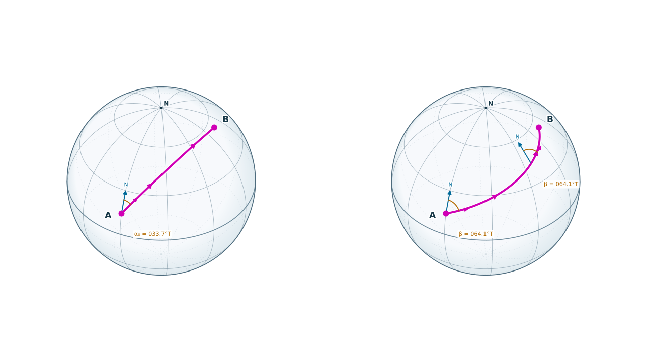
One precision note: this great-circle explanation assumes a spherical Earth. On an ellipsoidal Earth model such as WGS 84, the corresponding shortest surface path is a geodesic. The tool’s documentation should identify which model its calculation uses. [5]
Sources
- National Geospatial-Intelligence Agency, The American Practical Navigator, 2017 edition, Chapter 1: “Introduction to Marine Navigation.” Read the chapter (PDF).
- National Geospatial-Intelligence Agency, The American Practical Navigator, 2017 edition, Chapter 12: “The Sailings.” Read the chapter (PDF).
- NOAA Office of Coast Survey, “Nautical Cartography.” Read the explanation.
- Federal Aviation Administration, Pilot’s Handbook of Aeronautical Knowledge, Chapter 16: “Navigation.” Read the chapter (PDF).
- GeographicLib documentation, “Geodesics on an ellipsoid.” Read the documentation.
The numerical example was calculated for this explanation using a spherical Earth radius of 6,371.0088 km and 1 NM = 1.852 km; displayed results are rounded.
ABBREVIATION
- DD — Decimal Degrees.
- DDM — Degrees and Decimal Minutes.
- DMS — Degrees, Minutes, and Seconds.
- GPS — Global Positioning System.
- KML — Keyhole Markup Language.
- KMZ — A ZIP archive containing KML and any packaged resources.
- NM — Nautical Miles.
- TXT — Plain-text file.
- UTC — Coordinated Universal Time.
- WGS84 — World Geodetic System 1984.
DEFINITION
- Geodesic — The shortest surface path between two points on the reference ellipsoid.
- Initial azimuth — Direction of the geodesic as it leaves Point A.
- Rhumb line / loxodrome — A surface path crossing meridians at a constant angle.
- True bearing — A direction measured clockwise from geographic north.
- Interpolation — Estimating an intermediate position from samples before and after the requested time.
- Slant range — Direct spatial distance that includes a vertical separation; this tool reports horizontal surface distance instead.