
CONFIGURATION INDEX
| Item | Configuration |
|---|---|
| Document | GPS-RTK.html |
| Markdown source / build | GPS_RTK_R04.md / B261107 |
| File revision / build | R002 / B261109 |
| Content revision / build | R001 / B261106 |
| Date | 2026-11-09 |
| Approved source application | GPS RTK v0.5.0r03 B261106 |
| Standalone application | GPS RTK v0.5.0r03 B261106 |
| Source display / package build | B261106 / 2026110602 |
| Standalone package build | 2026110602 |
| Status | Prepared for project-owner review; not uploaded. |
Generic information
- The offline app help stays available even when not connected to internet.
- The online web help requires an internet connection.
- This is a reference tool only and not a substitute for knowledge, experience or approved operational data; always strictly use, adhere, follow and verify with approved operational data.
- If you do not have a FULL understanding of the tool, do not use it!
How to use the help section
🔴Disclaimer: A disclaimer is a legal statement designed to limit a company's liability or specify the boundaries of a product's warranty. It informs the user about what the product or company is not responsible for, or clarifies that certain information (like third-party software updates) is outside of the company's control. Impact: Legal/Financial. It protects the organization from lawsuits and sets realistic expectations for the product's performance or usage.
⚠️Warning: A warning alerts the user to potential hazards that could result in personal injury, death, severe data loss, or permanent damage to equipment. It is the most critical type of callout and must clearly explain the hazard, the consequences of ignoring it, and how to avoid it. Impact: High. Ignoring a warning can lead to physical harm or catastrophic system failure, or both.
🔼 Note: A note provides helpful, non-critical information to the user. It emphasizes points, clarifies steps, or offers background context that is not essential to completing the main task but improves the user's understanding. Impact: Low. Ignoring a note will not cause harm, damage, or data loss.
INTRODUCTION
GPS RTK is an iPad application for recording positions, tracks and MARKs, viewing maps and imported geographic references, and displaying calculated SWATH coverage. It can use a compatible RTK GNSS receiver with internet-delivered NTRIP corrections, the default position supplied by iPad Location Services, or a clearly identified simulation.
This is the global Help for the entire application.
GPS → RTK GNSS · OPEN SETUP → HELP opens the separate receiver-setup Help. The setup window is for connecting and checking equipment (the map is surrounded an orange frame); recording and MARK controls are on the main screen.
🔴Disclaimer: GPS RTK is for informational, educational and personal recording purposes only. It is not for primary, backup or emergency navigation, operational guidance, certified surveying or safety-critical decisions. Read the Disclaimer, including the common project restrictions on use while moving or in flight.
🔼 Note: This document describes the frozen v0.5.0r03 build. The current live-source behavior is explained below.
BASIC USAGE
1. Prepare a recording
- In a safe, stationary setting, open GPS RTK and confirm v0.5.0r03 B261106. The detailed build in GPS is 2026110602.
- Open GPS and select RTK GNSS, DEFAULT GPS, or SIMULATION. Allow Location access for default positioning and Bluetooth access for an RTK receiver when requested.
- For an RTK receiver, open RTK GNSS · OPEN SETUP, connect it in the GPS card, and configure corrections in NTRIP if required. Check STATUS, then select CLOSE SETUP.
- On the main screen, check the active source and whether the position is fresh. Selecting RTK GNSS expresses a preference; it does not guarantee that the active position is coming from that receiver.
- Choose a background through MAPS. If planning to work without internet, prepare and check local maps in advance with an internet connection.
- If coverage percentages are needed, define a test area in an empty live session and choose the SWATH width and side. A swath boundary is optional for recording tracks and MARKs.
- Tap START. Use MARK to save the latest fresh measured position. Use PAUSE to suspend track recording, START to resume, and STOP to finish the session.
- Open RECORDS → EXPORT CURRENT SESSION, or tap EXPORT. Save the resulting ZIP using the iPad share sheet and check that it reached the destination.
⚠️Warning: The person driving, flying or controlling a vehicle or vessel must not interact with the app while underway. The project Disclaimer requires a separate designated app operator and prohibits use during solo flight or while alone in charge of a moving vehicle or vessel. Background recording does not create an exception.
2. Find the controls
| Control | Purpose |
|---|---|
| MAPS | Select backgrounds, import GeoTIFFs, download or import tile packages, and show or hide map overlays. |
| GPS | Select the position-source preference; open RTK setup; define the live test area; configure live file rollover; start a new session; adjust Circle-to-Fix. |
| LAYERS (n) | Manage imported GeoTIFF charts. The number counts GeoTIFF entries, including entries currently hidden. It is not the number of all map overlays. |
| SWATH | View calculated coverage and choose the swath width and LEFT, CENTER or RIGHT placement. |
| KML | Import KML/KMZ reference points, lines and polygons, including polygon holes; fit or remove a reference. |
| RECORDS | Inspect counts and recent MARKs, choose the live map-export format, and export the current session. |
| D | Open the Disclaimer. |
| Certificate icon | Open Credits & Licences. |
| ? | Open global Help. |
| FIT ALL · FIT MAP · GRID | Fit local map content or toggle the geographic coordinate grid. |
| TIMING TESTS | Run the retained simulation scenarios and GPS-source checks; inspect timing and display diagnostics. |
The map has a persistent magenta + at its visual center and a magenta position arrow. They have different meanings: the + is a screen-center reference; the arrow represents the displayed position.
The strip above the map identifies the active source, recording state and background. The strip below the map includes position freshness, latitude/longitude, track in degrees true when available, track/MARK counts, coverage and map width. In RTK-preference mode it also shows Bluetooth, NTRIP and correction freshness. WIDTH in NM in this strip is the displayed map width, not the SWATH width.
3. Choose and understand the position source
| Preference in GPS | Main-screen behavior |
|---|---|
| RTK GNSS | Prefer a fresh, valid measurement from the connected RTK receiver. If that source becomes unavailable, automatically use a fresh DEFAULT GPS position when one is available. Return to RTK GNSS when usable receiver measurements resume. |
| DEFAULT GPS | Use the position supplied by iPad Location Services. This may come from the iPad or a supported external location accessory. No separate receiver connection card is needed for this path. |
| SIMULATION | Use the fixed artificial route and simulation timing controls. It does not represent measured GNSS or RTK accuracy. |
Pause or stop recording before changing this preference; the selector is disabled during recording or export. Automatic RTK/default handovers occur within a live session and are recorded as source changes. They start new track segments and break coverage continuity, so a line or swath is not manufactured across the handover.
⚠️Warning: A live session can contain both RTK and default-GPS records. Always inspect the active source and the per-record source in exports before interpreting a track as an RTK recording. The existence of an NTRIP connection does not turn a default-GPS position into an RTK measurement.
DEFAULT GPS depends on Location permissions, hardware, accessory compatibility and reception. Connecting an arbitrary Bluetooth GPS in iPad Settings does not make it a Core Location accessory. An iPad without built-in satellite GNSS may still return a location estimate, but the app cannot add missing hardware or guarantee satellite accuracy.
If neither eligible live source supplies a valid fresh fix, the last known position can remain visible as stale. A stale position cannot create a fresh MARK or extend coverage. The freshness window in this build is approximately three seconds, considering measurement age and processing delay; reconnecting or redrawing does not give an old position a new timestamp.
The RTK SETUP map and STATUS card describe the RTK receiver itself, even if the main screen has fallen back to DEFAULT GPS.
4. Connect a compatible RTK receiver
🔼 Note: the app has been successfully tested with the following GPS:
- SparkFun RTK Facet (built-in L1/L2 antenna and ZED-F9P module),
- NANO RTK Receiver (High-Precision Helical Antenna L1/L5).
Here are the steps to connect a compatible RTK receiver:
- Place the receiver where it has a clear sky view and configure it as a rover.
- Enable its compatible Bluetooth Low Energy (BLE) serial mode. The app uses the Nordic UART service for NMEA reception and RTCM forwarding. Compatibility requires this data interface; the generic RTK GNSS label is not a promise that every RTK receiver is supported.
- Disconnect another app, such as SW Maps, if it is using the same receiver connection.
- Open GPS → RTK GNSS · OPEN SETUP → GPS.
- Tap SCAN, select the intended receiver, and accept an iPad pairing request if one appears.
- Wait for incoming position data, then check STATUS for a fresh fix and the receiver's reported quality.
Project testing has included the SparkFun RTK Facet and the NANO RTK Receiver Pro. Firmware, message settings and hardware variants can affect behavior; these observations do not establish compatibility with every model or configuration.
The four setup buttons are GPS, NTRIP, STATUS and HELP. An orange border surrounds the setup map, with NOT FOR OPERATIONAL USE - RTK GNSS SETUP ONLY. The red CLOSE SETUP button returns to the main screen while retaining the same receiver and NTRIP connection. Reopening setup does not intentionally start a second connection or a new recording.
An unexpected Bluetooth disconnect can trigger reconnection. The app also attempts recovery after more than ten seconds without receiver notifications. Freshness expires sooner, so the main screen may fall back or become stale before a Bluetooth recovery attempt. An intentional DISCONNECT is a user command to stop that connection; it is different from a recoverable link interruption.
5. Configure NTRIP corrections
NTRIP delivers reference-station corrections over the internet. The app receives those corrections and forwards valid RTCM 3 frames to the receiver over BLE. The receiver computes its position solution.
| Setting | Meaning |
|---|---|
| Host | Caster hostname or supported IPv4 address, without http://, https:// or a path. |
| Port | The provider's connection port. Match the port and TLS setting to the provider. |
| Mountpoint | Exact, case-sensitive name of a correction stream. Do not include a leading slash. |
| Username / email | Provider-required user identity. This build requires a valid email-shaped username for an RTK2go correction connection. |
| Password | Password required by the chosen provider, if any. Free access does not necessarily mean anonymous access. |
| NTRIP V2 | Select version 2 when required; off uses version 1. |
| TLS encrypted connection | Use only with a caster endpoint that supports TLS. The app validates the server certificate. |
| Send fresh RTK GNSS GGA to caster every 10 seconds | Send the receiver's current position message when required by the service. See Section 7. |
| Reconnect after network interruptions | Allow the NTRIP client to retry after recoverable interruptions. |
Use your known working provider settings, then SAVE PROFILE and CONNECT. DISCONNECT stops NTRIP. A station selected in the list is not connected automatically.
For RTK2go, enter your email even if LOAD LIST succeeds without it. An anonymous station-list request is not proof that a correction-stream login will work. A missing or incorrect identity, wrong mountpoint or unavailable stream can result in rejection or a station list being returned instead of corrections.
The password is saved using the iPad Keychain; the profile contains the other settings. Usernames and passwords are excluded from the app's session-export fields. Location, receiver details and mountpoint information can still be present in exports.
⚠️Warning: With TLS disabled, NTRIP credentials and optional GGA position messages travel without TLS encryption. The TLS switch does not make a plain-TCP server support TLS.
🔼 Note: Compatible alternative casters can use the same fields. This build does not purchase a subscription, guarantee a caster's availability or independently verify that a provider's service remains free.
6. Find a free mountpoint without expanding the whole list
- In NTRIP → FREE MOUNTPOINTS, tap LOAD LIST.
- The app retains entries advertising RTCM 3 with fee = N.
- With a fresh RTK receiver position, the initial view shows up to the 10 nearest eligible entries, using approximate coordinates advertised in the caster table.
- Use Find a mountpoint to filter matching entries. SHOW ALL … MATCHES expands the results; SHOW TOP 10 shortens them again.
- Use UPDATE DISTANCES after moving. The reference position and distances stay fixed while browsing so the list does not continually reorder.
- Select a suitable stream, check the populated mountpoint and GGA requirement, then tap CONNECT.
Without a fresh RTK receiver position, the list is alphabetical. Entries without usable advertised coordinates follow those with a distance when distance ranking is available.
🔼 Note: Nearest in this list does not mean best corrections. Advertised coordinates may be approximate or inaccurate. Check station operation, receiver compatibility, supported signals, reference coordinates and provider instructions. A fee flag of N is a provider advertisement, not a contractual promise from GPS RTK.
7. Understand “GGA to caster”
A GGA message reports the rover's UTC fix time, latitude, longitude, solution-quality code, satellites used, HDOP, MSL altitude and related fields. Some correction networks need this position to generate a Virtual Reference Station (VRS) or choose corrections for the rover's area. A fixed-base mountpoint may not require it.
When the option is enabled and the caster has accepted the connection, the app sends a fresh RTK receiver GGA about every ten seconds. If fresh RTK data is unavailable, it waits; it does not substitute a DEFAULT GPS or simulated GGA. STATUS shows the sending state and count.
| Data | Direction | Purpose |
|---|---|---|
| GGA | Receiver → app → caster | Tell the correction service where the rover is. |
| RTCM | Caster → app → receiver | Supply correction data used by the receiver's positioning engine. |
Sending GGA does not itself improve the position or establish RTK FIX. It also shares the rover's location with the provider. The ten-second GGA interval does not set or reduce the receiver's measurement rate or the track-recording rate.
8. Read status and quality correctly
| Indicator | What it establishes | What it does not establish |
|---|---|---|
| BLE CONNECTED | The receiver data connection has been established. | That a fresh valid position or RTK solution is available. |
| NTRIP connected / awaiting RTCM | The caster connection has been accepted. | That valid correction frames are arriving. |
| Receiving RTCM corrections — green | Valid RTCM frames are being received. | That the receiver has achieved RTK FIX. |
| BLE submitted | Correction bytes/frames have been submitted through the Bluetooth path. | A receiver-level acknowledgment that every correction was used. |
| RTK FIX / FLOAT / DGNSS / GNSS | The receiver's reported solution quality. | A surveyed accuracy guarantee or image-alignment guarantee. |
| RTCM age | Time since the app received a valid correction frame. | The same quantity as receiver-reported correction age. |
| GST uncertainty | A receiver-estimated position uncertainty for a matching measurement epoch, when supplied. | A measured error against a known point. |
The main RTCM freshness indicator uses approximately five seconds since the last valid frame. Corrections that stop arriving can cause the receiver's reported solution to change later. GPS RTK preserves the receiver's actual reported quality; it does not infer FIX from a green connection indicator.
a) GGA quality indicators
Most accurate — typical ordering, not a guaranteed ranking of individual fixes
| GGA code | Solution | Typical interpretation |
|---|---|---|
| 4 | RTK FIX | Carrier-phase ambiguities have been fixed. Centimeter-level horizontal performance, often below 3 cm, may be achievable in good conditions with suitable corrections and an accurately positioned base. |
| 5 | RTK FLOAT | Ambiguities remain floating estimates. Decimeter-to-meter horizontal performance is possible, sometimes better or worse. FLOAT does not guarantee less than 10 cm. |
| 2 | DGNSS | Differential solution. Sub-meter to meter-level performance may be possible; code 2 does not guarantee less than 1 m. |
| 1 | GNSS | Autonomous satellite solution. A typical clear-sky horizontal range is approximately 1–5 m; actual error can be substantially larger. |
Least accurate — typical ordering
Sky view, reflected signals, satellite geometry, interference, base-coordinate errors, correction age and distance to the reference station can dominate performance. Vertical accuracy is usually poorer. The current RTK input accepts valid GGA quality codes 1, 2, 4 and 5; an invalid fix is not recorded as fresh.
GST uncertainty, HDOP and missing fields
GST reports estimated standard deviations for latitude, longitude and altitude. GPS RTK computes horizontal RSS sigma = √(latitude sigma² + longitude sigma²), in meters. For example, latitude sigma 0.020 m and longitude sigma 0.030 m give an RSS of approximately 0.036 m. This is not automatically a 95% confidence radius or an error bound.
GGA, RMC and GST are associated by measurement time. The app briefly holds a GGA epoch, up to about 150 ms, to assemble matching information without intentionally reducing the position rate. GST from a different epoch is not copied into a new position. If the receiver sends GST less often than GGA, some valid recorded positions will legitimately have no GST fields.
HDOP is a dimensionless satellite-geometry indicator; it is not meters of accuracy. SATS is the number used in the reported solution, not necessarily every satellite visible. DEFAULT GPS may provide Core Location horizontal/vertical accuracy estimates, but those are not relabeled as GST. Missing values remain blank or unavailable, never zero by assumption.
b) Time, height, speed and direction
The app distinguishes measurement time, arrival time and capture/processing time. With matching RMC, the receiver supplies the date as well as UTC time. GGA alone has time-of-day but no date, so the app infers a nearby date from the iPad and identifies that time basis. Keep the iPad's date and time correct.
GGA altitude is MSL height according to the receiver's geoid model. Where both fields exist, ellipsoid height = MSL height + geoid separation. These are not barometric altitude or height above the ground. The app does not apply antenna-height, lever-arm or survey-datum/epoch corrections. Speed is ground speed; course is track over ground in degrees true, not aircraft heading, magnetic heading or airspeed. Course may be unstable or unavailable when stationary.
9. Select backgrounds and overlays in MAPS
| MAPS control | Effect |
|---|---|
| U.S. BASE MAP LITE | Show or hide the bundled simplified U.S. reference layer. It is not a current road or navigation database. The global land mask provides general land/water context beyond detailed U.S. coverage. |
| APPLE MAP | Enable or disable Apple mapping. Recording continues when the background changes. |
| STREET / SATELLITE | Select the Apple map presentation while APPLE MAP is enabled. |
| IMPORT GEOTIFF | Import one or several supported .tif/.tiff maps from Files. |
| DOWNLOAD TILES | Open the Oxed download workflow. |
| SAVED TILES / IMPORT | Manage saved MBTiles/PMTiles packages or import another package. |
| Switch to the right of the two tile buttons | Show/hide all enabled local tile maps together. Off preserves files and each map's individual ON/OFF selection. |
Below the divider, individual switches control imported KML/KMZ, the dashed cyan test route, magenta recorded track, MARKs, SWATH coverage, 0.10/0.25 NM range rings, Circle-to-Fix, the 250 m test grid, and the alignment cross/reticle. These switches control visibility, not whether records are saved. The permanent magenta screen-center + is separate from the optional alignment-test geometry.
Apple imagery needs internet for reliable loading; cached imagery is not guaranteed offline. Turning APPLE MAP off restores the offline presentation. Local tile packages and GeoTIFFs can overlay the background and may cover the Apple imagery; hide them or adjust GeoTIFF opacity to compare layers. A locally rendered map can use MapKit for display even when Apple imagery is off.
🔼 Note: Downloading tiles through this app obtains Oxed/coalition.space raster tiles. It does not download Apple Street or Satellite imagery for offline use.
10. Pan, zoom, center and fit
| Control or gesture | Behavior |
|---|---|
| Pan / manual map gesture | Inspect another area; manual camera changes release automatic following. |
| − / + | Zoom out or in. |
| NORTH UP / TRACK UP ✓ | Toggle a north-oriented view and rotation according to available track over ground. |
| CENTER / CENTER ✓ | Center on the current/last-known position and enable following. The check mark indicates follow mode, not a quality guarantee. |
| RESET VIEW | Restore a north-up overview; release following. For live use, use the defined area or available position; otherwise show a broad fallback view. Simulation uses its reference area. |
| FIT MAP | Fit the enabled local tile-map extent. Disabled when local tiles are hidden or unavailable. |
| FIT ALL | Fit enabled local tile maps and visible GeoTIFF chart extents. It does not mean fit every recorded track, KML reference and Apple map in the app. |
| FIT in KML or LAYERS | Fit the particular reference or GeoTIFF. |
| GRID | Toggle the geographic latitude/longitude grid. |
The geographic grid, the Test grid · 250 m, and the download tile-selection grid are three independent displays. The dashed test route and 250 m test grid belong to SIMULATION and are not local live-receiver features. Geographic GRID is a coordinate reference, not a claim of survey accuracy.
For the informational Circle-to-Fix overlay, open GPS → CIRCLE-TO-FIX, choose a radius from 0.05 to 1.00 NM, and select USE MAP CENTER AS FIX to place its reference at the map center. Enable MAPS → Circle-to-Fix to display the circle, its reference marker and the line from the displayed position. This is a visual reference, not a flight maneuver instruction or a navigation command. Unlike MARK and DEFINE AREA, this control deliberately uses the map center.
The arrow and follow camera ease between received positions, for up to about one second. Smooth VIEWED growth progressively reveals coverage already confirmed by measurements. Neither animation changes the saved position, MARK coordinates or calculated coverage. Genuine gaps remain gaps; display smoothing does not predict an unmeasured route.
11. Import and manage GeoTIFFs
- Select MAPS → IMPORT GEOTIFF and choose one or more supported files.
- Keep GPS RTK in the foreground while importing. Cloud-hosted files must be available to the Files provider locally. The app copies originals into its own storage and prepares display data.
- Observe progress or select CANCEL IMPORT. Charts completed earlier in the batch remain available. Backgrounding cancels an active GeoTIFF import.
- Open LAYERS (n) to control each imported chart.
| GeoTIFF LAYERS control | Effect |
|---|---|
| ON / OFF | Show or hide this chart without removing it. |
| Opacity | Adjust from 0% to 100% in 5% steps. A visible chart at 0% opacity can still contribute to FIT ALL. |
| FIT | Frame this chart and release position following. |
| TO TOP | Draw this chart above overlapping charts. The top entry is drawn last. |
| Trash | Remove the app's imported chart copy and prepared tiles after confirmation. The original selected file in Files remains. |
The image's original margins, legends and blank portions remain part of the chart. Progressive refinement prepares useful nearby detail; hidden and fully transparent charts do not need active display preparation. Decoded display data can occupy more disk space than the compressed source.
Supported input in this build includes classic 8-bit palette, grayscale, RGB or RGBA TIFFs; strips or tiles; uncompressed, LZW, Deflate and PackBits data; supported WGS84/NAD83 geographic, Web Mercator and explicitly supported Lambert Conformal Conic 2SP georeferencing. PixelIsArea/PixelIsPoint and supported scale/tiepoint or affine transforms are interpreted.
BigTIFF, elevation TIFFs with 16/32-bit samples, JPEG-compressed TIFFs, UTM and other unsupported projections, antimeridian-spanning charts, multi-page images, separate color planes and non-top-left image orientation are outside this importer. Current limits include approximately 2 GiB per source file, 32,768 pixels per side, 400 million pixels total, and 64 MiB per decoded block. A file within those limits can still be unsupported for other reasons.
⚠️Warning: NAD83 coordinates are treated as approximate WGS84 for display, without datum-grid or epoch correction. A chart lining up visually does not validate centimeter accuracy. Check chart source, date, projection, scale and licence independently.
For placement or refinement problems, use HELP → EXPORT GEOTIFF DIAGNOSTICS and provide the resulting report with a screenshot. The report can include chart names, source hashes, projection, dimensions, corners, map center and display statistics.
12. Import saved MBTiles and PMTiles
- Obtain a supported raster package, for example from the Oxed download website.
- Open MAPS → SAVED TILES / IMPORT → IMPORT FROM FILES.
- Select an
.mbtilesor PMTiles v3.pmtilespackage containing supported PNG/JPEG raster tiles. Import one package at a time. - The file picker requests the current versioned app's Documents folder under On My iPad. iPadOS or the selected file provider can open somewhere else; browse to the file if necessary.
- Confirm the package is ON, then use its FIT control. Confirm the master tile switch in MAPS is also on.
Loose PNG/JPEG images, folders of tiles, ZIP downloads and vector-tile packages are not accepted as raster map packages. Unzip a delivery externally if it contains a supported package, then import that package.
Enabled maps work together. The highest locally available zoom at or below the requested view zoom supplies the detail; lower zooms can fill uncovered areas. At the same zoom, the most recently imported map wins where data overlap. Missing local tiles reveal the underlying background; the offline reader does not silently fetch missing tiles online.
An individual ON/OFF switch hides a package without deleting it. The trash control removes its imported copy after confirmation and keeps the original download. LOAD SYNTHETIC TEST GRID loads artificial test data; it is not a real map.
13. Download tiles inside GPS RTK
Open MAPS → DOWNLOAD TILES. The card has four numbered sections: ① Selection, ② KML references and blue pins, ③ Preview, and ④ Download.
① Selection
Choose a mode and one zoom level for the job:
| Mode | Selection |
|---|---|
| Around me | Area around the fresh active GPS position captured when PREPARE is pressed. In SIMULATION, this uses the simulated position. |
| KML waypoint | Areas around supported blue KML waypoints and manually placed blue pins. |
| KML route | A corridor along imported route lines. The distance entered is on each side; total width is twice that value. |
| KML area | Imported polygon areas. |
| Tapped tiles | Individual tiles selected on the map at the chosen zoom. |
The radius/distance field clears when selected so a replacement value can be entered. Review the value before preparing. Higher zoom levels require more tiles and storage; zooms 0–20 are offered, but provider coverage and the selected area still matter.
SELECT TILES ON MAP closes the card while you tap tiles. DONE returns to the card. Tapped selections at different zoom levels are retained separately.
② KML references and blue pins (optional)
Use IMPORT KML to select one or several KML files, depending on the selection made previously. This download-selection importer accepts KML; the separate main KML card also accepts KMZ.
Standard blue pushpins and blu-* paddle symbols are recognized as download waypoints. Other point colors are excluded from download selection and hidden in this workflow. Routes and polygons may have any source color. Use PLACE BLUE PINS ON MAP or ADD BLUE PIN AT MY POSITION to add points; a fresh active position is required for the latter. SHOW ON MAP frames the references. CLEAR removes these selection references and pins after confirmation, without deleting saved tile maps.
③ Preview
Tap PREPARE, then check the selected zoom, unique tile count, estimated size and VIEW SELECTION. The blue selection can be shown or hidden. For Around me, preparation captures a location; the selection does not follow you afterward. Prepare again to use a different location before starting a job.
④ Download
Tap DOWNLOAD. Progress separates cached tiles reused from tiles fetched during this run. A job supports up to 10,000 tiles and 512 MB of PNG data. Server pause/retry instructions are respected.
Use PAUSE and RESUME as needed. Downloads pause when the app enters the background; reopen the card and tap RESUME. Resume or discard an unfinished job before changing its selection. DISCARD removes the unfinished job while keeping cached tiles and imported maps.
When complete, select USE DOWNLOADED MAP to import/enable the result and turn on the master tile display. EXPORT MBTILES shares the completed package. Saved tiles have no automatic expiry; they can become outdated. Test the required area and zooms offline before relying on their availability for reference.
14. Import KML/KMZ geographic references
The main KML → IMPORT KML / KMZ control imports geographic points, lines, polygons and polygon holes. Each imported reference has FIT and REMOVE controls; review any import warnings. MAPS → Imported KML / KMZ controls visibility.
Standard symbols replace custom icons. Network links and image overlays are not loaded. A successful import does not mean every feature supported by another KML viewer is implemented here.
LOAD BUNDLED ALIGNMENT KML provides a fixed test reference with shapes, a polygon hole and an alignment cross. It is useful for comparing alignment while switching backgrounds, panning, zooming and changing orientation. It is not a locally surveyed boundary and may be far from your current position.
Importing KML does not define the SWATH target. Download-selection KML, main-map KML references and the live coverage rectangle are separate features. This build does not import main-SPOTMAP .spotmap packages.
15. Define a live test area and use SWATH
The app provides both:
- a live test (based on current location) to quickly test and become familiar with the SWATH feature;
- and a custom SWATH input (KML files only, no KMZ files) for real operational usage.
a) Custom SWATH
For the app to recognize an imported KML polygon as a SWATH area:
If created in Google Map (or similar tool):
| Setting | Required value |
|---|---|
| Boundary / line color | Orange #FFAA00 |
| Area / fill color | Orange #FFAA00 |
| Area opacity | Exactly 80% — equivalent to 20% transparency |
| Fill | Enabled |
- Line width and line opacity do not affect recognition;
- Use an opaque outline for visibility only;
- Use a closed polygon, not an open path (minimum 3 vertices);
- All KML files imported as a SWATH, but not matching the boundary line color, and the area color and opacity will be displayed, but not recognized as an active SWATH area to survey.
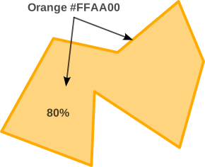
If editing the KML directly (with a text editor or similar):
- Orange fill at 80%:
cc00aaff - Orange outline at 100%:
ff00aaff
The NOT VIEWED (not covered) areas remain orange, opacity at 80%. The app generates the green VIEWED coverage automatically.
b) Test function
This is a test function only, to easily check you RTK GPS and the SWATH function; not for any real operational use.
The live test area is a north-aligned rectangle centered on the latest fresh raw position from the active live source. It is fixed geographically after creation. It is not placed at the magenta map-center + by panning the map.
- Export an existing session before beginning another.
- Select GPS → NEW SESSION and confirm. Remain in an empty session; create the area before recording track points or MARKs.
- Obtain a fresh position at the intended center. If the rectangle must be centered on the RTK receiver, check that the active source is RTK GNSS rather than DEFAULT GPS fallback.
- Enter the East–west, m and North–south, m dimensions. Each must be between 20 and 5,000 m; the initial inputs are 100 m by 100 m. The current area definition is limited to positions within approximately 85° north/south latitude.
- Tap DEFINE AREA AT FRESH GPS POSITION. Use RESET VIEW to see an overview of the defined area if needed, and enable MAPS → SWATH coverage.
- In SWATH, select width and LEFT, CENTER or RIGHT, then return to the main screen and tap START.
The SWATH slider covers 15.24–304.8 m (50–1,000 ft). CENTER divides the selected total width between both sides; LEFT or RIGHT puts the full width on that side of travel. Width/side changes affect subsequent movement and break continuity while retaining earlier viewed areas.
| Display | Meaning |
|---|---|
| Orange NOT VIEWED | Portion of the defined target not yet covered by the app's recorded swath geometry. |
| Green VIEWED | Calculated covered portion, based on accepted recorded positions and configured width/side. |
| Magenta track | Recorded position history within the current display window. |
| Viewed percentage | Calculated covered target area divided by the defined target area. Repeated overlap is not counted as new target area. |
For example, a 100 m × 100 m rectangle has a nominal area of 10,000 m² in the app's local geometry. Leaving and re-entering it is allowed: the track can continue outside, while the percentage concerns the defined target. No surveyed KML file is required for this test. Without a defined target, track and MARK recording still work, but a meaningful target-coverage percentage is unavailable.
The current control requires a fresh position at the intended center; it does not offer arbitrary rectangle placement at a desk.
Stationary position scatter and unstable course can produce a green patch or dot. This behavior does not establish movement or actual observation. Smooth growth is a presentation effect; it does not change the coverage calculation.
⚠️Warning: VIEWED does not prove that terrain, an object or a surface was actually seen, photographed, inspected or fully covered. No terrain visibility, antenna offset, camera footprint, obstruction or legal-boundary validation is implied. Do not maneuver solely to fill the display.
16. Record, pause, stop and MARK
| Button | Behavior |
|---|---|
| START — green | Start or resume track recording when the session permits it and a usable live position is available. |
| PAUSE — yellow | Stop adding track/coverage while retaining the session. Connections and available live positioning continue. |
| STOP — red | Finish the session. START cannot resume a stopped session; use NEW SESSION for another recording. |
| MARK — orange | Save the latest valid fresh raw fix, source and available GNSS metadata. It does not save the smoothed arrow position or the map-center +. |
| EXPORT — pink | Prepare a shareable ZIP from the current saved session. |
MARK is independently available when a fresh position exists, including while track recording is paused or stopped. It does not resume the track. Repeated stationary MARKs may have identical or nearly identical coordinates.
Live recording retains accepted fresh measurements from the active source at their received measurement rate. Duplicate and out-of-order fixes are rejected rather than made fresh. Stale intervals, reception gaps, pause/resume, source handovers and relevant configuration changes break track/coverage continuity. Losing NTRIP alone does not stop recording valid RTK-receiver positions; quality can change from FIX to FLOAT, DGNSS or GNSS.
The recent display is bounded: approximately the latest 7,200 track points and 300 MARKs are retained for live presentation; RECORDS lists the most recent 30 MARKs. At 4 Hz, 7,200 points is about 30 minutes; at another rate, the duration differs. Earlier saved records remain in the session and its full export. A shortened on-screen track is not by itself evidence of lost recording.
17. Understand storage, recovery and background operation
In GPS → LIVE GPS RECORDING FILES, select 1, 5, 10 or 15 minutes for file rollover; the default is five minutes. The recorder also rolls over when a journal part approaches its size limit. Rollover closes one part and starts another within one logical session. It does not pause recording or divide coverage solely because a new file was opened.
Recovery checkpoints are requested approximately every minute and at recording changes. They preserve coverage state and journal progress so relaunch can restore a checkpoint and replay the remaining records rather than rebuilding the whole session from the beginning. Checkpoint saving is asynchronous; the latest request is not a guarantee that a checkpoint has already reached storage.
A recovered live session returns PAUSED. Check the restored counts/area, receiver connection, active source and freshness before START. A recovery checkpoint is not an external backup. Do not manually edit, rename or delete live journal parts or manifests to troubleshoot a recovery warning; preserve the files and report the exact message.
Closing RTK SETUP simply closes a window. Switching to another app or locking the screen invokes iPadOS background behavior. Live positioning/recording uses Bluetooth and Location Services background capabilities, but uninterrupted operation depends on permissions, hardware, power, networking and iPadOS. Verify lock-screen/background behavior on the actual configuration. Force-quitting the app must not be treated as continued recording.
SIMULATION pauses in the background. Tile downloads also pause and need RESUME; an active GeoTIFF import is cancelled. These are separate from the live-recording policy.
The app's visible container uses its versioned application name. Legacy internal subfolder names such as Map Prototype Stage 2 R03, Facet or facet-… can remain for saved-data compatibility; they do not identify a different running build. Keep original map packages and important recording ZIPs backed up outside the app before deleting or replacing an installation.
18. Export and interpret the files
For live sessions, choose KMZ (default) or KML in RECORDS → Map file in ZIP. A ZIP contains one selected map representation, rather than duplicating a full KML and KMZ by default.
| Live-session ZIP member | Contents |
|---|---|
.csv |
Track/MARK rows with coordinates, times, source and available GNSS/connection/coverage-configuration fields. |
.jsonl |
Detailed saved capture records, one JSON record per line. |
.kmz or .kml |
Track segments and MARKs for viewing in compatible mapping software. KMZ contains the KML. |
_events.jsonl |
Connection, source, quality, stale/recovery and recording events available for the session. |
_settings.json |
Saved session settings, including the boundary and recording configuration. |
_diagnostics.txt |
Diagnostic counters and context for interpreting the recording. |
_manifest.json |
Session/build identity, export counts, position sources and saved-file cutoffs. |
The live KML/KMZ is for track geometry and MARKs. It clamps geometry to ground for viewing and is not an altitude survey or a complete export of imported maps, imagery, KML references and the green/orange coverage display. Use CSV/JSONL for the recorded measurement metadata; do not infer height from the external viewer's terrain rendering.
Exports have unique names containing source/session information, UTC time, build revision and an export identifier; simulation exports also identify the scenario. Preserve the ZIP's original name when sharing test results.
A live export takes a fixed cutoff of saved data. Recording can continue while the export is prepared; later records belong to a subsequent export. Progress and CANCEL EXPORT are available. Cancellation removes the incomplete export and retains the recording. File rollover and bounded export processing reduce large-session memory pressure, but do not guarantee unlimited storage, runtime or export size.
Simulation retains the R05 five-file ZIP: CSV, KML, capture JSONL, timing JSONL and diagnostics TXT. Its separate archive path retains a roughly 32 MB limit; do not assume the live-export behavior applies to the simulation packager.
Export the current session before selecting NEW SESSION or running another controlled scenario. Older journals remain saved, but this build's export button targets the current session; it is not a full historical-session browser.
⚠️Warning: Exports can reveal precise locations, times, receiver details, mountpoints and observations. Review them before sharing. An external viewer may omit metadata or render segments differently. Check the CSV/JSONL and manifest when completeness matters.
19. Run the nine timing scenarios
For informal simulation, GPS offers 1×, 5× and 10× speed. At 1× the simulated movement is 20 m/s with one independent sample per second. The bottom PLAY SIM / PAUSE SIM control operates simulation movement separately from the recording controls. The fixed five-pass route is near Grand Prairie, Texas; its target is 1,200 × 800 m. It does not relocate to the iPad or RTK receiver. Controlled tests set their own 1× configuration.
Select SIMULATION in GPS, then open TIMING TESTS. RUN TEST starts a new saved scenario at 1× with a 150 m centered swath. Export the previous test first. Allow the route to finish for a controlled verdict; STOP, PAUSE, backgrounding or SWATH edits make that controlled run incomplete. Map changes, pan/zoom and MARK are permitted.
| Scenario | What it exercises |
|---|---|
| LIVE SIMULATION | Independent one-per-second generation while the interface is used. |
| REFERENCE ROUTE | Fixed 1 Hz measurement times and 20 m steps; expected unchanged-route coverage is 89.5604%. Actual execution delays are still measured. |
| DELAYED DELIVERY · 5 s | Hold five positions at second 20 and release them in order at second 25. Old history must not become a fresh live position. |
| MISSING POSITIONS · 5 s | Drop samples 20–24. Track and coverage must break across the resulting measurement gap. |
| DUPLICATE / OUT OF ORDER | Repeat sample 30, then send sample 10 after sample 31. Reject both without moving the live position backward. |
| SLOW PROCESSING · 5 s | Pause the recording worker while generation continues; measure queue depth and processing lag. |
| SLOW STORAGE · 5 s | Inject a journal delay and measure storage latency separately. |
| INTERFACE STALL · 5 s | Deliberately freeze the interface around second 20 while the recording worker continues. Taps are temporarily ignored. |
| R02 TIMING REGRESSION | Replay 299 historical positions and their original UTC timing, including a 3.436-second gap; expected coverage is 89.2479% with matching breaks. |
Smooth VIEWED growth is on by default. Toggle it briefly to compare stepped and smooth presentation; this does not change the saved geometry or invalidate a timing run.
A consistent reference timeline does not conceal execution delay: generation, delivery, processing and storage times are measured separately. Pending, dropped, rejected, duplicate and out-of-order counts explain where samples went. Display callback diagnostics describe interface timing, not a measured GPU frame rate.
RUN GPS SOURCE CHECKS uses a separate temporary session to exercise selection, gaps, MARKs, old-file decoding and mixed-source exports. Other Help/STATUS checks cover parsers, tile reading and download geometry. Synthetic PASS results do not prove live Bluetooth, permissions, NTRIP, background operation or long-duration reliability.
20. Troubleshooting
| Symptom | Useful checks |
|---|---|
| Receiver absent from SCAN | Power, BLE serial mode, Bluetooth permission, compatible service, range, and another app holding the connection. |
| BLE connected but no fresh RTK fix | Clear sky view; receiver rover mode; current valid GGA output; supported quality; iPad time; incoming NMEA counters. A transport connection alone is insufficient. |
| Main screen says DEFAULT GPS although RTK was selected | Check the RTK preference, BLE readiness and receiver freshness. The fallback is intentional in this build. STATUS in RTK SETUP remains receiver-specific. |
| NTRIP or LOAD LIST times out | Internet path, caster/port/TLS combination and provider availability. A network-path indicator is not proof the caster is reachable. Preserve the exact message; do not repeatedly change a known working profile without a reason. |
| “Station list instead of corrections” | Exact mountpoint, username/email, password, provider authorization and stream availability. RTK2go requires an email for correction access in this build. |
| Corrections arrive but there is no FIX | Receiver signal conditions, correction compatibility, reference distance/coordinates, correction age and convergence. Green RTCM is not FIX. |
| GST is blank or intermittent | Receiver GST output and timing relative to GGA; inspect exports and matching receiver logs. Do not replace missing uncertainty with zero. |
| No orange NOT VIEWED area | A rectangle must be defined in the live session; enable SWATH coverage and use RESET VIEW. KML alone does not create the target. |
| Stationary green dot or changing direction | Position scatter and unstable/undefined course can create local coverage. Check raw measurements rather than interpreting the display as motion. |
| Map is blank offline | APPLE MAP may have no cached imagery; enable prepared local resources and verify saved coverage/zoom. |
| Imported tiles are invisible | Master MAPS tile switch, per-package ON/OFF, FIT, actual extent/zoom and another opaque overlay. |
| GeoTIFF fails or appears offset | Supported encoding/projection, source completeness, chart georeferencing and datum assumptions; export GeoTIFF diagnostics. |
| Track has gaps or old points disappear | Distinguish recorded segment breaks from the 7,200-point display window. Compare events, full export and receiver logs. |
| Relaunch shows PAUSED | Expected recovery behavior. Check restored data and fresh positioning before START. |
| Export appears to omit the last movement | It includes the saved cutoff at export start. Export again for later records; compare manifest counts and timestamps. |
| START is disabled after STOP | Export, then create a NEW SESSION. A stopped session cannot resume track recording. |
For a useful issue report, provide the exact app/build, iPad/iPadOS and receiver/firmware, selected and active source, map mode, what you did, expected/observed behavior, UTC interval, screenshot and original session ZIP. Add a matching receiver log if available. Remove passwords and other unnecessary private information.
ABBREVIATIONS — A TO Z
| Abbreviation | Definition / explanation |
|---|---|
| BLE | Bluetooth Low Energy; the wireless serial link used for supported RTK receiver data and correction forwarding. |
| CRC | Cyclic Redundancy Check; RTCM 3 frames are checked using CRC-24Q. Passing a CRC checks frame integrity, not position accuracy. |
| CRS | Coordinate Reference System; describes how coordinates relate to the Earth. |
| CSV | Comma-Separated Values; tabular export format. |
| DGNSS | Differential Global Navigation Satellite System; positioning using differential corrections. |
| EPSG | Identifier commonly used for coordinate reference systems and coordinate operations in the EPSG dataset. |
| GGA | NMEA Global Positioning System Fix Data message: time, position, quality, satellites, HDOP and height information. |
| GNSS | Global Navigation Satellite System; general term covering satellite positioning systems. |
| GPS | Global Positioning System; also used in the interface as a familiar position-source label. |
| GST | NMEA GNSS Pseudorange Error Statistics; receiver-estimated uncertainty components. |
| HDOP | Horizontal Dilution of Precision; dimensionless effect of satellite geometry on horizontal positioning. |
| JSONL | JSON Lines; a text format with one JSON object per line. |
| KML | Keyhole Markup Language; geographic features and presentation in XML. |
| KMZ | ZIP-compressed KML package. |
| LCC | Lambert Conformal Conic map projection; this importer supports specific 2SP configurations. |
| MSL | Mean Sea Level; a height reference distinct from ellipsoid height and height above ground. |
| NAD83 | North American Datum of 1983; approximated as WGS84 by this build's supported GeoTIFF display path. |
| NM | Nautical mile; 1,852 meters. |
| NMEA | National Marine Electronics Association; NMEA 0183 defines text messages used here, including GGA, RMC and GST. |
| NTRIP | Networked Transport of RTCM via Internet Protocol; delivery of GNSS correction streams over an internet connection. |
| ODbL | Open Database Licence; the licence used for OpenStreetMap data. |
| RMC | NMEA Recommended Minimum GNSS Data message; includes UTC date/time, validity, position, ground speed and track. |
| RSS | Root Sum of Squares; the horizontal GST combination √(latitude sigma² + longitude sigma²). It is different from Bluetooth RSSI. |
| RSSI | Received Signal Strength Indicator; a Bluetooth signal-strength measurement, commonly displayed in dBm. |
| RTCM | Radio Technical Commission for Maritime Services; its GNSS standards include the correction frames used here. |
| RTK | Real-Time Kinematic; positioning using carrier-phase measurements and reference-station corrections. |
| SATS | Satellites used in the receiver's reported position solution. |
| TLS | Transport Layer Security; encrypted transport with server-certificate validation when supported by the caster. |
| UBX | u-blox binary message/log format; a receiver's UBX log is separate from this app's session export. |
| UTC | Coordinated Universal Time; the time reference used for receiver epochs and export timestamps. |
| VRS | Virtual Reference Station; correction-service technique that can use the rover's reported location. |
| WGS84 | World Geodetic System 1984; a global reference system used for geographic coordinates. |
DEFINITIONS
| Term | Meaning in GPS RTK |
|---|---|
| Caster | Server distributing named NTRIP correction streams. |
| Mountpoint | Case-sensitive name of one caster stream. |
| Rover | Receiver measuring the user's position using satellites and, when available, corrections. |
| Base / reference station | Receiver or network supplying reference observations/corrections. A second personal receiver is not required when using a suitable NTRIP service. |
| Fix / epoch | A position measurement and its measurement time. |
| Fresh / stale | Whether a measurement is recent enough and valid for the current live use. Connection status alone does not establish freshness. |
| Source preference / active source | What the user selected versus which eligible source currently supplies measurements. |
| Session / file part | One logical recording versus one periodically closed journal file within it. |
| Segment break | An explicit discontinuity preventing a track or coverage bridge across an interruption or source change. |
| MARK | A saved point using the latest eligible raw measurement and its available metadata. |
| Swath / target | The configured strip of calculated coverage versus the defined area against which coverage is assessed. |
| Checkpoint | A saved recovery state referencing already saved records; not a substitute for an external backup. |
| Export cutoff | Fixed saved position in the journals used for one export while recording may continue. |
| MBTiles / PMTiles | Map archive formats. This build imports the supported raster subset, not every payload permitted by the formats. |
| GeoTIFF | A TIFF image with geographic reference information; support depends on encoding and projection. |
RELATED DOCUMENTS
- GPS RTK · Credits & Licences.
- GPS RTK · Disclaimer and Important Safety Notice.
- RTK SETUP → HELP: receiver-focused reference available inside the app; a separate Markdown extraction exists in the project.
- Project website and common Disclaimer online. Internet is required. This document does not claim that a new GPS RTK Help page has been published.
DOCUMENT BASIS AND REVISION HISTORY
Behavior was checked against the frozen package's main interface, receiver/source selection, NMEA assembly, recording/export, map-import and download implementations. The document retains the project Help organization and notice syntax. References to future integration into the main SPOTMAP application are project plans, not features of this standalone build.
| Content revision / build | Change |
|---|---|
| R001 / B261106 | First consolidated GPS RTK global Help for v0.5.0r03, including current default-GPS fallback and maps/import/download features. Prepared for review; not integrated into the frozen app. |
File revision R02 / B261107
Corrected the two emoji-based Note labels to the frozen project SVG notice format. Supplied all three standard notice assets alongside this source, with explicit intrinsic dimensions for Markdown display. Verified every Note, Warning and Disclaimer label against DOC-NOTICE-01. The Help wording and user edits are preserved; the content revision remains R001 / B261106.
File revision R03 / B261107
Replaced all 12 external-image notice labels with the exact embedded Unicode labels used in the user-provided How to use the help section.md: 🔴Disclaimer, ⚠️Warning, and 🔼 Note. The icons require no separate images folder or ZIP. Updated the file revision and notice-format metadata. The Help wording, user edits and shared inclusions are preserved; the content revision remains R001 / B261106.
File revision R04 / B261107
Restored the owner-approved DOC-TABLE-01 configuration index: the exact two columns and ten fixed rows, with unchanged labels and order. Removed the nonstandard rows, including Shared notice icons, and updated the document identity and applicable configuration values. The embedded notice icons, Help wording and user edits are unchanged; the content revision remains R001 / B261106.